The Tennessee Water Resources Research Center (TNWRRC) is a federally designated state research institute supported in part by the U.S. Geological Survey. It serves water resource experts in academia, government, and the private sector, and the diversity of its staff's background and expertise positions the Center to establish productive partnerships. TNWRRC is part of the Institute for a Secure and Sustainable Environment (ISSE) at the University of Tennessee, Knoxville.
New from USGS:
- Increased intensity of agricultural best management practices predicted to have modest effects on nitrogen and phosphorus loading to streams on a regional scale.
What is already known on this topic?
Nitrogen and phosphorus losses from agricultural areas have degraded the water quality of downstream rivers, lakes, and oceans. Agricultural best management practices (BMPs), such as cover crops, conservation tillage, and no-till practices, are commonly used to reduce these nutrient losses.
What is added by this report?
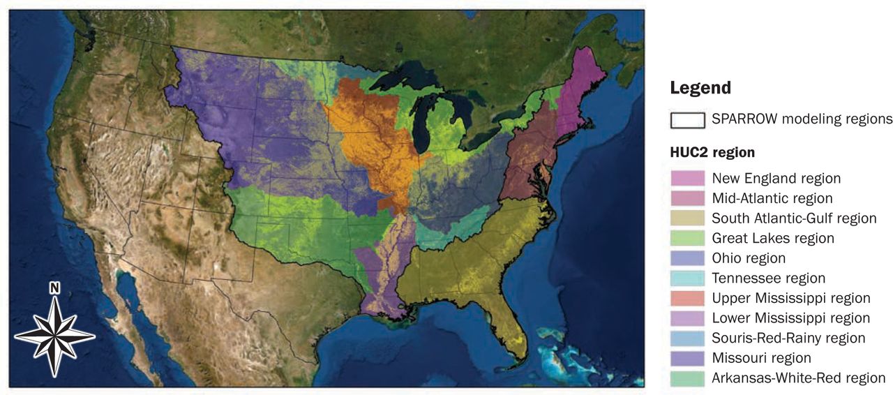
Although BMPs are commonly used to reduce nutrient losses, research is limited as to the extent of nutrient reduction on a regional scale. This study estimates the influence of cover crops, conservation tillage, and no-till BMPs on nutrient loads and yields from agricultural areas to streams in the Midwest, Northeast, and Southeast using SPARROW(SPAtially Referenced Regression On Watershed attributes) models.
What are the implications for water availability?
Estimates of the influence of BMPs on water quality will allow resource managers to assess the effectiveness of BMPs toward reaching nutrient-reduction targets in waterbodies at risk of nutrient pollution.
For more information, contact: Victor Roland.
Citation: Roland II, V.L., Garcia, A.M., Saad, D.A., Ator, S.W., Robertson, D.M., and Schwarz, G.E., 2022, Quantifying regional effects of best management practices on nutrient losses from agricultural lands: Journal of Soil and Water Science, https://doi.org/10.2489/jswc.2022.00162
-
Chemical mixtures common in small U.S. streams causing concern for aquatic life. Mixtures of organic chemicals are ubiquitous in small U.S. streams, reports a new study by the U.S. Geological Survey. In many streams the mixtures could be affecting stream organisms. USGS scientists collected 3 to 12 water samples from 305 small streams across four major regions (Northeast, Southeast, Pacific Northwest, and Coastal California) of the U.S. as part of the USGS Regional Stream Quality Assessment. The samples were analyzed for 389 organic chemicals comprising pharmaceuticals, pesticides, and wastewater-indicator compounds. Pesticides and pharmaceuticals are designed to have a biological effect. For more information, contact Paul Bradley.
- Bakken Shale unconventional oil and gas production has not caused widespread hydrocarbon contamination to date in groundwater used for water supply A new USGS study reports that shale-oil and -gas production from a major production area in Montana, North Dakota, and South Dakota has not caused widespread hydrocarbon contamination to date in nearby aquifer zones used for drinking-water supply.
For more information, contact Pete McMahon, Subject line: Bakken Shale and Groundwater. Data used in the study can be found here. - New Study: Atrazine concentrations have decreased in streams and rivers across the United States
- New Study: New sampling approach reveals pesticides in streams occur more often and at higher concentrations than previously measured
- New online SPARROW (SPAtially Referenced Regression On Watershed attributes) models and interactive mappers for the Southwest, Pacific, Southeast, Midwest, and Northeast regions of the U.S. are now available from the U.S. Geological Survey. Review the regional reports for the Southwest, Pacific, Southeast, Midwest, and Northeast. Learn more about SPARROW models and applications.
 What’s in Your Stream? Get Online to Find Out! Stream Quality Viewer Shows Contaminants, Nutrients, and Stream Health— A new update to an online interactive tool for learning about pesticides, nutrients, and overall stream health in major regions of the U.S. is available from the U.S. Geological Survey’s Regional Stream Quality Assessment. Users now can access results for the Northeast and Pacific Northwest regions, along with results for the Midwest and Southeast regions made available in 2018. Read more here.