 An Urban Waters Report Card (UWRC) for Tennessee is under development to provide MS4s (Municipal Separate Storm Sewer Systems) a way to track incremental improvements to their streams—from stormwater management to stream rehabilitation efforts. TNWRRC is working with TDEC (Tennessee Department of Environment and Conservation); the cities of Nashville, Chattanooga, Memphis, and Knoxville; and the counties of Hamilton, Shelby, and Knox. These jurisdictions are MS4 permittees. The UWRC will not be a regulatory program. Its only purpose is to help MS4 programs.
 Despite considerable effort by these MS4s, in many cases streams will continue to fail to meet their designated uses, and remain on the impaired waters list. UWRC proposes a grading scale to provide an assessment scheme that demonstrates any incremental enhancements of a stream’s condition. Such a scheme is more informative to the local stakeholders including the MS4 professional and administrative staff, political leaders, and the public.
The planned framework of the UWRC is simple and intuitive. A number of categories would be graded. A composite grade would be recorded for each stream assessed. A working group comprised of representatives from TDEC, TNWRRC, and the MS4s shown above are meeting to discuss the details of the proposed categories and grading schemes.
Despite considerable effort by these MS4s, in many cases streams will continue to fail to meet their designated uses, and remain on the impaired waters list. UWRC proposes a grading scale to provide an assessment scheme that demonstrates any incremental enhancements of a stream’s condition. Such a scheme is more informative to the local stakeholders including the MS4 professional and administrative staff, political leaders, and the public.
The planned framework of the UWRC is simple and intuitive. A number of categories would be graded. A composite grade would be recorded for each stream assessed. A working group comprised of representatives from TDEC, TNWRRC, and the MS4s shown above are meeting to discuss the details of the proposed categories and grading schemes.
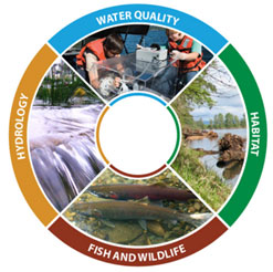
After much discussion during a July 29th working group meeting, the four categories were selected with some suggested metrics. The four categories are: Watershed Hydrology, Water Quality, Stream Corridor, and Community Value. Below is a summary of the categories agreed upon by the attendees:
- Watershed Hydrology
- Treated runoff volumes from Stormwater Control Measures (SCMs)
- Effective impervious area (similar to SCMs/Retrofits)
- Flashiness Index
- Indices of Hydrological Alteration (IHAs)
- Land Use % Area (urban forest canopy, parks and open space): converted or preserved.
- Water Quality
- Fine sediment (TSS), bacteria (pathogens), nutrients (P/N, periphyton), metals, toxics
- Indices of Biotic Integrity (TMI sub-metrics/ IBI sub-metrics)
- Other Pollutants (with WQ standards)
- Stream Corridors
- Physical Habitat – substrate, meso- and micro-habitat structure
- Riparian Buffer – setbacks, easements, vegetation composition and structure
- Hydrological Connectivity: floodplains and wetlands, biological refugia patches
- Biodiversity – plant/wildlife terrestrial/aquatic
- Channel Stability: Rapid geomorphic Assessment (RGA); bank erosion index
- Fish barriers (AOP), infrastructure crossings
- Community Value
- Access, recreation
- Aesthetics, trash
- Socioeconomic factors
Development of the metrics per category and how to score each will be the next phase of this project. The development of a scoring system and desktop/field protocols for measurement may require an expert’s assistance. Development of a draft report card would include the following steps:
- Determine the number of categories for stream evaluation.
- Set up workshop around each category to determine the number of metrics, protocols, and break-points for each metric.
- Compile the protocols and metrics into a web-based document and test in the field.
- Set up workshop to prepare an example report card and a map.
- Present draft report card for wider use and revisions to other interested cities, counties, and organizations.
- Create a guidebook, and provide support and training for the program.
If you are interested in additional information, please contact the TNWRRC.